From Cartography Class to National Conference: A Maxwell Graduate’s Research Journey
By Jacob Spudich
September 3, 2026
Amelia Rudolph, a geography and citizenship and civic engagement dual major, presented undergraduate research at the largest gathering of geographers in North America.
Amelia Rudolph came to Maxwell with questions about how people make decisions and left with research that reached a national audience.
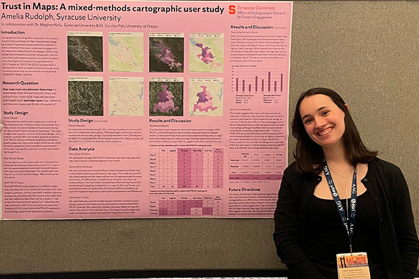
When she graduated in May, Rudolph wrapped up a senior year that included a study with faculty on trust in maps. After helping to design the survey, creating maps and analyzing the data, she traveled to San Francisco in March to present the findings at the American Association of Geographers annual meeting—the largest gathering of geographers in North America. She was one of just a few undergraduates there.
“I think a lot of people assumed I was a master’s student,” Rudolph said. “Which felt cool, that I was doing work that was at that level.”
The trip was made possible by Syracuse University’s Student Office for Undergraduate Research and Creative Engagement, also known as SOURCE, which covered her travel, lodging and meals.
“A major benefit of research is being able to apply the theory you learn in a classroom to more deeply explore,” said Rudolph who majored in geography as well as citizenship and civic engagement.
Rudolph’s research examined how much people trust what they see on a map and what design choices shape that trust. The project grew out of a broader conversation in the field about how people consume and evaluate information, and whether maps carry the same credibility concerns as other media.
My biggest takeaway from our research is that the way you ask a question is just as important as what question you’re asking. Considering multiple perspectives and collecting feedback in more than one way strengthens your findings, and eventually your solutions.”
Amelia Rudolph ’26 B.A. (Geog/CCE)
Rudolph and her collaborators designed a survey to test which map elements—such as titles, legends, data sourcing and satellite imagery—affect how trustworthy viewers find a map to be. She pointed to Federal Emergency Management Agency flood maps as an example of the high stakes, as they shape insurance rates, inform where people choose to live and guide how cities invest in infrastructure.
The research results were mixed. The team found that specific design elements didn’t significantly affect trustworthiness scores, and participants frequently pointed to satellite imagery and thematic maps as relatively trustworthy.
“My biggest takeaway from our research is that the way you ask a question is just as important as what question you’re asking,” Rudolph said of the undertaking. “Considering multiple perspectives and collecting feedback in more than one way strengthens your findings, and eventually your solutions.”
Rudolph’s collaborators included a Maxwell mentor, Meghan Kelly, assistant professor of geography and the environment, as well as Carolyn Fish, a professor at the University of Oregon. Kelly delivered the AAG Cartography and Mapping Specialty Group’s Early Career Scholar Keynote at the March conference.
“If I didn’t have a mentor like Dr. Kelly, who pushed me to take on a project like this, I wouldn’t have applied to a highly regarded master’s program,” said Rudolph, noting that she will soon begin studies at Penn State. “Research provided me with evidence that I was capable of graduate-level work, and that really strengthened my application.”
The work continues. Kelly said the team plans to submit a journal article to an invited special issue of Digital Geography and Society, and Rudolph plans to present the project at the North American Cartographic Information Society annual meeting this fall.
Rudolph’s additional Syracuse experiences included an internship at Syracuse’s Neighborhood and Business Development Office, working with newly resettled immigrants and refugees, and work with Syracuse Community Geography, which partners with organizations in need of maps and data. She also worked in the department’s Cartography Studio, producing maps for faculty publications.
Rudolph said her biggest lesson as an undergraduate was to take advantage of every opportunity to work with faculty and conduct research. “If I had let self-doubt prevent me from doing an internship with Syracuse Community Geography, conducting research or working as a cartographer with the Cartography Studio, I would not be where I am today,” she said. “My portfolio has grown so much, I was able to travel and present my research, and I have the most supportive network of people both at Syracuse and in the larger geographic and cartographic world.”
Related News
School News
Oct 12, 2026
School News
Oct 5, 2026
Research
Oct 1, 2026
School News
Sep 24, 2026